Print Story
X

Experts in Pakistan dismiss the impression that India has anything to do with floods in Pakistan
"India released excessive water from ‘its’ dams to ‘our’ rivers without prior information which has caused floods in Pakistan, damaging life and property," these are the first two lines of a column written by a contributor in a leading Urdu newspaper on September 16. The perception is shared by many.
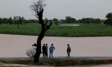
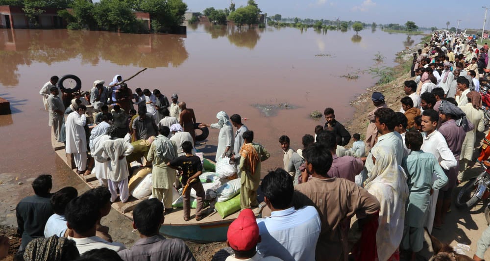
The recent floods, according to experts, induced by heavy monsoon rains left more than 450 dead and a swathe of destruction on both sides of the border. Many people in Pakistan and a section of media allege that current floods in Pakistan have been worsened because Indian authorities opened the gates of the Baglihar dam at River Chenab.
The common perception in Pakistan is that India deliberately causes floods in Pakistan. On September 12, Chief of Jamaat-e-Islami, Sirajul Haq, put the responsibility of current floods on India. "These floods are the fifth Indian attack on Pakistan," he said.
A day before that, Jamaat-ud-Dawa Chief, Hafiz Saeed, had also blamed India for floods and electricity and water crises in Pakistan. He has coined the term ‘Indian water aggression’ on Pakistan and has been using it continuously in his speeches against India.
Experts in Pakistan dismiss these impressions. "India has to do nothing with these floods, they are heavy rainfall induced floods," says Mirza Asif Baig, Pakistan’s Chairman of the Indus Water Commission. "We have severe rains in catchment areas of Neelam-Jhelum River. There were also severe rains in catchment areas of Punch River, which caused heavy floods in Pakistani side of Kashmir.
He says that there are some run-of-the-river dams in the Indian held Kashmir on Chenab but none of them has high storage capacity. "The valley of Chenab is narrow and building a big storage dam is not an easy task there," he says, adding, "Our relationship with India is such that we are not ready to see the whole issue impartially. India continuously shares data about floods with us on hourly basis during high flood situation. India provides data of water follow in Chenab from Akhnoor from where it takes only 3-4 hours to reach Marala headwork."
"India is also experiencing calamitous floods. Whom should India accuse of flooding it?" asks Ramaswamy R. Iyer, former Secretary Water Resources in the government of India. A leading expert on regional cooperation on river water and a member of the UNSGAB High Level Expert Panel on Water and Disaster, an adjunct to the UN Secretary-General’s Advisory Board on Water and Sanitation, Iyer says once floods occur, they will necessarily move downstream. "They cannot be held back. As India is upstream, the floods are bound to flow from India to Pakistan, not the other way round. This doesn’t mean that India is flooding Pakistan."
Iyer says the Indus Water Treaty (IWT) was made precisely to protect Pakistan (a) from deprivation of water and (b) deliberate flooding by India, that quite stringent, extensive and elaborate provisions were built into the treaty. "So long as the IWT is working, Pakistan has nothing to worry about. As a matter of fact, very few lower riparian have the kind of protection vis-a-vis the upper riparian that Pakistan has vis-a-vis India," he says.
"If at any time Pakistan feels that India is violating the treaty, it can invoke the arbitration clause. It is not true that India can flood Pakistan from Baglihar, but assuming that it can, the floods will submerge vast areas in India, including the Salal Project, before reaching Pakistan."
In 2010, the then Indian High Commissioner to Pakistan, Sharat Sabharwal, gave his country’s detailed view over India’s ‘water war’ with Pakistan while addressing an event in Karachi. "We have never hindered water flows to which Pakistan is entitled, not even during the wars of 1965 and 1971 as well as other periods of tense relations and we have no intention of doing so."
Sabharwal also said that those who allege that India was acquiring the capacity to withhold Pakistan’s share of water completely ignore the fact that this would require a storage and diversion canals network on a large scale. "Such a network simply does not exist (in Indian held Kashmir) and figures nowhere in our plans."
India has least control over Indus as only 20 per cent of its catchment area falls in the Indian territory while rest falls either in Pakistan or China.
"India has built three big run-of-the-river dams on Chenab while several small ones but they cannot be used to manipulate floods on the river downstream," says Syed Jamaat Ali Shah, former Indus Commissioner. He says that after 1988 floods both countries deliberated on the issue on high level and in 1989 India agreed to share data on Chenab water flow from July 1 to October 10 on hourly basis from Akhnoor. "Jammu Tavi River which joins Chenab at Marala also observes huge flash flood when it rains in the catchment area. This year during peak season 0.35 to 0.4 million cusec of water flowed from this river. India also shares information on this river but in case of huge floods we only have a margin of 3-4 hours to react," he says.
Shah says that after 1988 floods Pakistani authorities decided to strengthen Meteorology Department so that, instead of relying solely on Indian data, we would have our own data of rains in advance to forecast floods. "But, so far, we have not been able to achieve that goal, we still depend on the Indian data. India is not a friendly country but what we have been doing is also questionable. Our people use India as an excuse to hide their incapability."
The total capacity of Taremon head in Jhang district, says Shah, is to discharge 0.645 million cusec water. "Chenab and Jhelum rivers join here. During peak flood in Chenab after September 5, our authorities released around 1,50,000 cusecs of water from Mangla in River Jhelum. The flood water of over 3,50,000 cusecs also reached there. Taremon has the capacity of over 6,45,000 cusecs but authorities had to breach Atthara Hazari bund even when water flow was over 5,00,000 cusecs because its gates are old and some could not even open to discharge water," he says.
Shah says that if we would have adequate information about rains and floods, authorities could have discharged water from Mangla dam a few days earlier, which could cross Taremon before Chenab’s water reached there and they would not have to breach the bund.
"We have not conducted surveys of rivers after 1970s. Cross sections of rivers are not available here. Breaching points were also decided in early 1970s. Now the situation has changed, hundreds of thousands of people have been living near these breaching points now. I think now they need to build permanent channels on these breaching points, instead of submerging huge population," he says.
Senior officials in Pakistan Meteorological Department also deny that any water released by India has been the cause of any flooding in Pakistan. "It was a rain induced flood and we issued an alert on September 3 that heavy rains in Chenab catchment areas could cause heavy flooding," says Muhammad Riaz, Chief Meteorologist of Flood Forecasting Division.
He admits that his department lacks resources to install modern gadgets to forecast rains and floods. "We are doing a good job in the given resources but it has been becoming tough to forecast weather due to the phenomenon of climate change," he says. Riaz says his department has no cooperation with the Indian meteorological department at any level. "India does not share forecast with us but only the water flow from one point. We need to extend cooperation with India."
Another top official of the Met department says cooperation does not exist even among Pakistani departments. "A representative of Pakistan Met office used to attend meetings of Indus Water Commissions but for the last three years the authorities have stopped inviting us to these meetings. This practice used to help Met office to update its information on the Indian side of dams and infrastructure on rivers."