Biparjoy makes landfall along India-Pakistan border, inches closer to Sindh
The landfall process is expected to continue till midnight, says PMD
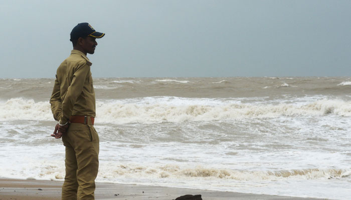
The cyclone Biparjoy, dubbed as “very severe cyclonic storm”, has made landfall along Indian Gujarat coast (Jakhau port) and Pakistan-India border, the Pakistan Meteorological Department (PMD) said in a statement on Thursday.
The weather forecast department said in its latest update that the cyclone is at a distance of 150km from Keti Bandar, 200km from Thatta and 245km from Karachi around latitude 23.0°N and longitude 68.3°E.
“The landfall process will get complete by midnight. Maximum sustained surface winds are 100-120 Km/hour gusts 130 Km/hour around the system center and sea conditions being rough/phenomenal with maximum wave height 20-25 feet,” it added.
The India media reported that entire process of the landfall is expected to take around six hours and it will completely touch land around midnight.
During the landfall, the windspeed is expected to be between 115-125km per hour, gusting to 140km per hour.
"The landfall process has started. The cyclone is still 70km away and is moving towards the coast. It will take around 6 hours for the cyclone to cross the sea into the land," Dr M Mohapatra, the chief of the Indian Meteorological Office was quoted as saying.
Nearly 100,000 people have been evacuated and moved to shelters ahead of the cyclone's landfall from Indian coastal areas.
The Indian authorities have also suspended commercial operations at Gujarat's Jamnagar airport till Friday.
‘Biparjoy slows down in Pakistan’
Meanwhile, according to Federal Minister for Climate Change Sherry Rehman, cyclone Biparjoy has "slowed down" and will not make landfall before nightfall in Pakistan.
Speaking during a press conference in the federal capital earlier today, the federal minister said it was previously expected that the cyclone would hit Sindh’s Keti Bandar around 11am.
“But, since the speed at which it is moving has slowed by 6-7km, its times of landfall is delayed and it is now expected to hit the shores until after dusk.”
However, the senator stressed that while the cyclone had "slowed down", its core was still "intense", and the areas identified earlier as vulnerable still needed to stay alert.
“We had earlier marked four districts at risk. Thatta, Badin, Sujawal and Malir (Karachi). Now, since the trajectory is towards the northeast, the Tharparkar region also needs to be aware of the impact of the cyclone,” she said.
“We will update you regularly since these storms are unpredictable,” Rehman said, adding that the storm was still heading towards the northeast.
She said that strong winds and heavy rainfalls are still expected to go up to 300mm in some areas, adding that while the cyclone had moved away from Karachi, its effects would be seen in these areas.
“A flood warning has been given in the sea,” she said. She warned that winds are blowing at a speed of 120-140km/h while waves of 30 feet and more are rising in the sea.
The PMD said maximum sustained surface winds are 120-140km per hour and gusts 150km per hour around the system center and sea conditions being rough/phenomenal around the system center with maximum wave height 25 feet.
Dust/thunderstorm-rain with few heavy falls and accompanied by squally winds of 60-80km per hour are likely in Karachi, Hyderabad, Tando Muhammad Khan, Tando Allayar, Shaheed Benazirabad and Sanghar districts on Thursday and Friday.
Dust/thunderstorm-rain with isolated heavy falls likely in Hub, Lasbella and Khuzdar districts of Balochistan today and tomorrow (Friday). Strong winds may cause damage to loose and vulnerable structures (Kutcha houses) including solar panels etc.
Storm surge of three to four meters (10-13 feet) is expected at the land falling point Keti Bandar and around which can inundate the low-lying settlements.
Sea conditions along the Sindh coast may get very rough/ high (2-2.5 meters) and rough/ very rough (2 meters) along the Balochistan coast (Sonmiani, Hub, Kund Malir. Ormara and surroundings).
Sindh coastal areas feel impact of cyclone
Amid approaching cyclone Biparjoy, heavy to moderate rains were reported from various districts of Sindh including Badin, Thatta, Hyderabad, Mirpurkhas, Karachi and others.
Heavy rainfall accompanied with strong winds damaged several houses, electricity poles and trees in Badin district.
Electricity supply has also been suspended for last two days in fishermen's settlements along the coastline in the district while around 1,000 displaced fishermen are in relief camps in Badin.
Similarly, several parts of Karachi including Quaidabad, Malir, Gulshan-e-Iqbal, University Road and other areas received light to moderate rains.
Highest rainfall of 5mm was recorded in Quaidabad 5 mm followed by Jinnah Terminal 4.4mm at and 4.2mm University Road, the Met department said.
In Thatta district, local administration said army and civil agencies are jointly carrying out rescue and relief operations.
More than 80 thousand people were rescued from the coastal areas, the Thatta district administration said in a briefing.
Eleven relief and medical camps have been set up in Thatta district, Deputy Commissioner Ghulam Farooq Soomro said.
45 camps have been established in Badin, Thatta and surrounding areas where 34 thousand people are present, the deputy commissioner added.
He said food and other basic necessities including dry milk was being provided to the displaced persons in the camps.
In the next phase, he said the preparations to deal with the effects of the storm will be completed.


-
 Security forces gun down 30 terrorists in multiple IBOs in KP: ISPR
 -
 MQM-P calls for new province in Sindh
 -
 US report validates Pakistan military edge over India: PM
 -
 Banned TTP poses serious threat to Pakistan security: UNSC panel
 -
 CM Afridi clarifies remarks on by-poll after ECP requests army deployment
 -
 Dubai sees 3.2m Pakistani passengers in 2025 as airport sets new milestone
 -
 Security forces kill 23 Indian proxy terrorists in KP's Kurram
 -
 Pakistan to construct island to boost oil exploration: report