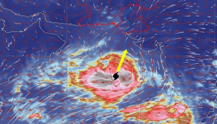
Very severe cyclone Biparjoy 840km away from Karachi
In light of the development in the storm's progress, section 144 has been imposed in Karachi
ISLAMABAD: With a 25-28 feet maximum wave height, the Very Severe Cyclonic Storm (VSCS) “Biparjoy” over the east-central Arabian Sea is maintaining its intensity and has been further tracked north-northeastward during the past 12 hours, the Pakistan Meteorological Department (PMD) warned Saturday.
An alert issued by the Pakistan Meteorological Department (PMD) on Saturday stated that the storm now "lies near Latitude 17.3°N & Longitude 67.4°E at a distance of about 840km south of Karachi, 830km south of Thatta & 930km southeast of Ormara".
Previously, the storm was 1,040 kilometres south of Karachi, 1,020, kilometres south of Thatta, and 1,110 kilometres southeast of Ormara.
"Maximum sustained surface winds are 130-140 Km/hour gusts 150 Km/hour around the system centre and sea conditions being phenomenal around the system centre with maximum wave height 25-28 feet.
"The favourable environmental conditions (sea surface temperature of 30-32°C, low vertical wind shear & upper-level divergence) can intensify the system further into an Extremely Severe Cyclonic Storm (ESCS) for at least next 24 hours," the PMD notification added.
The PMD said that Biparjoy is most likely to track further in the north-northeast direction towards Southeast Sindh-Indian Gujarat coast under the existing upper-level steering winds.
"Karachi is monitoring the system and will issue an update accordingly," it added.
Possible impact
- Fishermen are advised not to venture into the open sea from tomorrow, 11 June 2023 onwards till the system is over as the Arabian Sea conditions may get very rough/high accompanied by high tides along the coast.
- With its probable north-northeast track, the rain-thunderstorm with some heavy falls & squally winds is expected on the Sindh-Makran coast from 13 June evening/night onwards.
- Squally (high-intensity) winds may cause damage to loose & vulnerable structures.
- Sea conditions are very high/phenomenal around the system canter with a maximum wave height of 25-28 feet.
- Section 144 imposed in Karachi
- In light of the development in the storm's progress, section 144 was imposed in Karachi earlier today.
- Entry to the port city's beaches was banned, a notification from Karachi Commissioner announced.
- The city's administration has banned fishing, sailing, swimming, and bathing at seas within the territorial limit of Karachi owing to the threat from June 11 till the "end of the storm."
- The notification read that the decision had been taken to avoid any untoward incident of shipwreck or drowning.
Section 144 imposed in Karachi
In light of the development in the storm's progress, section 144 was imposed in Karachi earlier today.
Entry to the port city's beaches was banned, a notification from Karachi Commissioner announced.
The city's administration has banned fishing, sailing, swimming, and bathing at seas within the territorial limit of Karachi owing to the threat from June 11 till the "end of the storm."
The notification read that the decision had been taken to avoid any untoward incident of shipwreck or drowning.
-
Security forces gun down 30 terrorists in multiple IBOs in KP: ISPR
-
MQM-P calls for new province in Sindh
-
US report validates Pakistan military edge over India: PM
-
Banned TTP poses serious threat to Pakistan security: UNSC panel
-
CM Afridi clarifies remarks on by-poll after ECP requests army deployment
-
Dubai sees 3.2m Pakistani passengers in 2025 as airport sets new milestone
-
Security forces kill 23 Indian proxy terrorists in KP's Kurram
-
Pakistan to construct island to boost oil exploration: report


