ISLAMABAD: Official documents, Google maps and the alignment prepared by NESPAK all show that no ‘zigzag’ exists on the 4.5km-long Paswal Road stretch of the proposed Rawalpindi Ring Road (R3) contrary to what is mentioned in the fact-finding report on the aborted project.
The minority inquiry report of Rawalpindi Commissioner Gulzar Shah, accepted by the government for implementation, claimed wrongdoing in the alignment of the R3 from Hakla at the M1 Motorway to Sangjani in Islamabad at the N-5 (also known as the GT Road) and described this 4.5km-long section as the Paswal Zigzag.
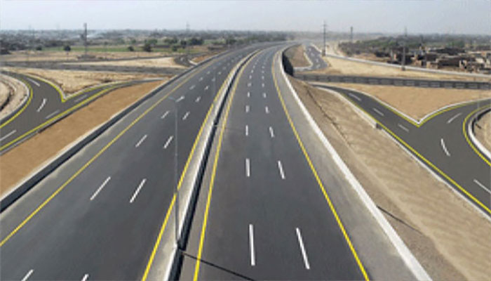
The technical documents of the request for the proposal (RFP) show that NESPAK designed the 4.5km stretch for a speed of up to 120km per hour, thus belying the contention that the road zigzags. Google maps and the NESPAK alignment demonstrate that this is a wide curve, allowing speeds of up to 120km per hour -- like a motorway.
The right of way (ROW) recommended by NESPAk is 200ft, proposing to use 88ft of the existing Paswal Road and compulsorily acquiring the remaining land from housing societies and local landowners. This modality, as per NESPAK and the inquiry report of the Rawalpindi deputy commissioner (DC), had been adopted for the R3 because the land along this stretch was very expensive as it was widely colonised and already connected to the motorway through the Army Welfare Trust (AWT) Society Sangjani interchange. The Google view further displays that the area is densely populated by colonies and local settlements that start from following the Paswal Road, leaving no other option available.
Another aspect shared by a senior official privy to the R3, is that the Project Management Unit (PMU) of the venture was only responsible for the alignment in the Punjab part of the R3 (65km) and the last 1.4km of the proposed ring road was the responsibility of the Capital Development Authority (CDA) once it would enter village Sangjani located in the Islamabad Capital Territory (ICT) in Zone 2. Prime Minister Imran Khan had directed that the alignment decision and land acquisition of this portion would be done by the CDA, which has so far taken no action. The land in the 3.2km Punjab portion along Paswal Road has also not been acquired and no payment made to the landowners.
Official documents explain that there are no zigzags in the Paswal Road alignment of the R3 and the road is as straight as can be, designed as it is for vehicular speeds of 120km per hour.
The 1.4 km stretch proposed to pass through Sangjani is un-acquired and no alignment has been designed by the CDA yet. This will be done with the approval of the federal cabinet as indicated by the CDA member, planning & design, in his letter to the Rawalpindi Development Authority (RDA), available with The News.
The official said the R3 at this stretch was proposed to be a six-lane double carriageway with controlled access having a fence on both sides. As per the advertised RFP, this portion will have a service road on both sides so as to facilitate commuting by the urban dwellers and nearby villages. However, the commissioner’s report said that the Paswal stretch will have no service road.
According to official documents, the alignment of 4.5km extending from the Hakla interchange on the intersection of the Western corridor of the China-Pak Economic Corridor (CPEC) and M1 Motorway up to Sangjani on the GT Road overlaps with the old Sangjani-Fateh Jang road, also called the Paswal Road.
This is the provincial government’s road with an 88ft ROW. There are numerous developed housing societies along the Paswal Road including the Engineers Housing Society, Margalla View Society, AWT Society and Veterans Society, which were developed almost a decade ago.
Out of the 4.5km length, 3.2km falls in the Taxila tehsil of Punjab and the proposed R3 passes through Paswal village owned by the famous Khattar clan. This is their centuries-old ancestral land. The next village is Budhana, which falls partly in Taxila and partly in the ICT.
After 3.2km, the R3 will enter village Sangjani and after 1.4kms it will merge into the Margalla Avenue, to be started on the prime minister’s directions. While reviewing the progress of the R3 recently, the PM had directed that the ring road should be connected to Margalla Avenue at Sangjani after passing through Zone 2, which on the ground means village Sangjani in sector C-17.
A relative of senior bureaucrat Dr Tauqir Shah told The News that all the vacant land in sector C-17 belongs to his Syed family of Sangjani for the last many centuries. He said that the Syed family does not have any real estate projects on the land, which is used for farming -- although as per the CDA land use regulations, housing colonies, high-rise towers, marquees, up to six-storey educational institutions and petrol pumps can be built on this land since the private sector is allowed development in Zone 2 on the western side of the GT Road.
The Google earth review of land around the so-called Paswal Zigzag shows that it is not possible for the proposed R3 to reach the starting point of Margalla Avenue without passing through the Syed family’s land.
The fact-finding inquiry committee, formed by the Punjab government, comprised three Rawalpindi administration officials – the commissioner, deputy commissioner and additional commissioner, coordination. All of them wrote their own reports.
The letter of the CDA member, planning & design, said that the part of the R3 falling in Islamabad is proposed to be connected to the Margalla Avenue across the GT Road. The grid-iron pattern of the Islamabad sectors have a provision for construction of principal roads in between the sectors having a ROW of 600ft. As per the Islamabad master plan, the R3 should be connected to the Margalla Avenue in the alignment of the Principal Road. Unfortunately, the ROW of the Principal Road has been encroached by a big grid station installation. Its shifting will not only require substantial resources but also time which might not be a feasible solution.
Therefore, the letter said, the alternate solution is to bypass the grid station and the congested built- up area in sector C-17 and extend the R3 up to the starting point of the Margalla Avenue in its ROW falling in the northern periphery of sector C-16. Some part of the R3 may fall in the sectoral limits of C-17 during the alignment/bypassing of physical constraints. Aligning the R3 within the sectoral limits will require approval of the federal cabinet. However, the CDA has no objection if the R3 is connected with the Margalla Avenue across the GT Road by constructing an interchange, the letter said.


